


Le Cellier 2011-05-22

phila128
User
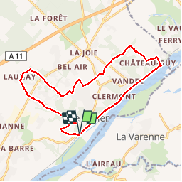

Length
16.4 km

Max alt
83 m

Uphill gradient
262 m
Km-Effort
19.9 km

Min alt
4 m

Downhill gradient
263 m
Boucle
Yes
Creation date :
2014-12-10 00:00:00.0
Updated on :
2014-12-10 00:00:00.0
--
Difficulty : Easy

FREE GPS app for hiking
 SityTrail
IGN / Geographical institutes
SityTrail Plus
The world is yours!
About
Trail Walking of 16.4 km to be discovered at Pays de la Loire, Loire-Atlantique, Le Cellier. This trail is proposed by phila128.
Positioning
Country:
France
Region :
Pays de la Loire
Department/Province :
Loire-Atlantique
Municipality :
Le Cellier
Location:
Unknown
Start:(Dec)
Start:(UTM)
624637 ; 5241340 (30T) N.
Comments
Très sympa mais le balisage ne correspond pas.
circuit très agéable